Original Articles
Vol. 51 No. 1 (2020)
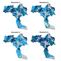
Definition of a land quality index to preserve the best territories from future land take. An application to a study area in Lombardy (Italy)
Publisher's note
All claims expressed in this article are solely those of the authors and do not necessarily represent those of their affiliated organizations, or those of the publisher, the editors and the reviewers. Any product that may be evaluated in this article or claim that may be made by its manufacturer is not guaranteed or endorsed by the publisher.
All claims expressed in this article are solely those of the authors and do not necessarily represent those of their affiliated organizations, or those of the publisher, the editors and the reviewers. Any product that may be evaluated in this article or claim that may be made by its manufacturer is not guaranteed or endorsed by the publisher.
Received: 6 August 2019
Accepted: 17 December 2019
Accepted: 17 December 2019
2023
Views
952
Downloads
143
HTML