Riparian vegetation as a marker for bankfull and management discharge evaluation: The case study of Rio Torbido river basin (central Italy)

Submitted: 17 December 2020
Accepted: 14 February 2021
Published: 28 June 2021
Abstract Views: 865
PDF: 616
HTML: 11
Publisher's note
All claims expressed in this article are solely those of the authors and do not necessarily represent those of their affiliated organizations, or those of the publisher, the editors and the reviewers. Any product that may be evaluated in this article or claim that may be made by its manufacturer is not guaranteed or endorsed by the publisher.

Authors

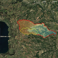
Bankfull discharge estimation is a crucial step in river basin management. Such evaluation can be carried out using hydrological and hydraulic modelling to estimate flow-depths, flow velocities and flood prone areas related to a specific return period. However, different methodological approaches are described in the scientific literature. Such approaches are typically based either on the assumption that the bankfull discharge corresponds to a narrow range of return periods, or on the correlation to the river geomorphological or local descriptors, such as vegetation. In this study, we used high-resolution topographic data and a combined hydrological-hydraulic modelling approach in order to estimate bankfull discharge in the ungauged basin of Rio Torbido River (Central Italy). The field survey of plant species made it possible to investigate the link between the riparian areas and the bankfull discharge. Our results were in line with previous studies and showed a promising agreement between the results of the hydraulic modelling and the plant species present in the investigated river cross sections. The plant species position could be indeed used for a preliminary delineation of the riparian areas to be verified more deeply with the hydrological-hydraulic approach.

Dimensions

Altmetric

PlumX Metrics

Downloads

Download data is not yet available.

Citations

Annis A., Nardi F., Petroselli A., Apollonio C., Arcangeletti E., Tauro F., Belli C., Bianconi R., Grimaldi S. 2020. UAV-DEMs for small-scale flood hazard mapping. Water 12:1717. DOI: https://doi.org/10.3390/w12061717
Arcement G.J., Schneider V. 1989. Guide for selecting Manning’s roughness coefficients for natural channels and flood plains. US Geological Survey Water Supply Paper 2339.
Bendix J., Hupp C.R. 2000. Hydrological and geomorphological impacts on riparian plant communities. Hydrol. Process. 14:2977-90. DOI: https://doi.org/10.1002/1099-1085(200011/12)14:16/17<2977::AID-HYP130>3.0.CO;2-4
Bertoldi W., Drake N.A., Gurnell A.M. 2011a. Interactions between river flows and colonizing vegetation on a braided river: exploring spatial and temporal dynamics in riparian vegetation cover using satellite data. Earth Surf. Process. Land. 36:1474-86. DOI: https://doi.org/10.1002/esp.2166
Bertoldi W., Gurnell A.M., Drake N.A. 2011b. The topographic signature of vegetation development along a braided river: results of a combined analysis of airborne lidar, color air photographs and ground measurements. Water Resour. Res. 47:W06525. DOI: https://doi.org/10.1029/2010WR010319
Biedenharn D.S., Copeland R.R, Thorne C.R., Soar P., Hey D.R. 2000. Effective discharge calculation. US Army Corps of Engineers.
Boreggio, M., Bernard, M. Gregoretti C. 2018. Evaluating the influence of gridding techniques for Digital Elevation Models generation on the debris flow routing modelling: a case study from Rovina di Cancia basin (North-eastern Italian Alps). Front. Earth Sci. 6:89. DOI: https://doi.org/10.3389/feart.2018.00089
Calenda G., Campolo F., Cosentino C., Guercio R. (a cura di). 1994. Valutazione delle piene nei bacini delle sezioni idrografiche di Roma e Pescara. In La valutazione delle piene in Italia-Rapporto Nazionale di Sintesi, Bozza, CNR-GNDCI, Allegato F. Available from: http://www.idrologia.polito.it/gndci/rapporti/RmPe.htm
Copeland R.R., Biedenharn D.S., Fischenich J.C. 2000. Channel-forming discharge. US Army Corps of Engineers.
D.P.R. 14 April 1993. Atto di indirizzo e coordinamento alle regioni recante criteri e modalità per la redazione dei programmi di manutenzione idraulica e forestale. Available from: https://www.gazzettaufficiale.it/eli/id/1993/04/20/093A2321/sg
Džubáková K., Molnar P., Schindler K., Trizna M. 2015. Monitoring of riparian vegetation response to flood disturbances using terrestrial photography. Hydrol. Earth Syst. Sci. 19:195-208. DOI: https://doi.org/10.5194/hess-19-195-2015
Errico A., Pasquino V., Maxwald M., Chirico G.B., Solari L., Preti F. 2018. The effect of flexible vegetation on flow in drainage channels: Estimation of roughness coefficients at the real scale. Ecol. Engine. 120:411-21. DOI: https://doi.org/10.1016/j.ecoleng.2018.06.018
Forzieri G., Castelli F., Preti F. 2012. Advances in remote sensing of hydraulic roughness. Int. J. Remote Sens. 33:630-54. DOI: https://doi.org/10.1080/01431161.2010.531788
Forzieri G., Degetto M., Righetti M., Castelli F., Preti F. 2011. Satellite multispectral data for improved floodplain roughness modelling. J. Hydrol. 407:41-57. DOI: https://doi.org/10.1016/j.jhydrol.2011.07.009
Grimaldi S., Petroselli A., Nardi F. 2012. A parsimonious geomorphological unit hydrograph for rainfall-runoff modelling in small ungauged basins. Hydrol. Sci. J. 57:73-83. DOI: https://doi.org/10.1080/02626667.2011.636045
Gurnell A.M. 1995. Vegetation along river corridors: hydrogeomorphological interactions changing River Channels. John Wiley and Sons, Chichester, UK, pp. 237-260.
Gurnell A. 2014. Plants as river system engineers. Earth Surf. Process. Landf. 39:4-25. DOI: https://doi.org/10.1002/esp.3397
Hughes F.M.R. 1997. Floodplain biogeomorphology. Progr. Phys. Geogr. Earth Environ. 21:501-29. DOI: https://doi.org/10.1177/030913339702100402
Knighton A.D. 1984. Fluvial forms and processes. Arnold, London, UK.
Louckova B. 2011. Vegetation-landform assemblages along selected rivers in the Czech Republic, a decade after a 500 - year flood event. River Res. Appl. 28:1275-88. DOI: https://doi.org/10.1002/rra.1519
Masterman R., Thorne C.R. 1975. Predicting influence of bank vegetation on channel capacity. J. Hydr. Div. ASCE 101:871-84.
Merritt D.M., Scott M.L., Poff N.L., Auble G.T., Lytle D.A. 2010. Theory, methods and tools for determinating environmental flows for riparian vegetation: riparian vegetation-flow response guilds. Freshwater Biol. 55:206-25. DOI: https://doi.org/10.1111/j.1365-2427.2009.02206.x
Mockus, V. 1957. Use of storm and watershed characteristics in synthetic hydrograph analysis and application. American Geophysical Union, Pacific Southwest Region, Sacramento, CA, USA.
Navratil O., Albert M.B., Herouin E., Gresillon Jâ€M. 2006. Determination of bankfull discharge magnitude and frequency: comparison of methods on 16 gravel-bed river reaches. Earth Surf. Process. Landf. 31:1345-63. DOI: https://doi.org/10.1002/esp.1337
Petts G.E., Gurnell A.M. 2005. Dams and geomorphology: research progress and future directions. Geomorphol. 71:27-47. DOI: https://doi.org/10.1016/j.geomorph.2004.02.015
Pellicani R., Parisi A., Iemmolo G., Apollonio C. 2018. Economic risk evaluation in urban flooding and instability-prone areas: the case study of San Giovanni Rotondo (Southern Italy). Geosciences 8:112. DOI: https://doi.org/10.3390/geosciences8040112
Peña F., Nardi F. 2018. Floodplain terrain analysis for coarse resolution 2D flood modeling. Hydrology 5:52. DOI: https://doi.org/10.3390/hydrology5040052
Tabacchi E., Lambs L., Guilloy H., Planty-Tabacchi A.M., Muller E., Decamps H. 2000. Impacts of riparian vegetation on hydrological processes. Hydrol. Process. 14:2959-76. DOI: https://doi.org/10.1002/1099-1085(200011/12)14:16/17<2959::AID-HYP129>3.0.CO;2-B
Tarquini S., Isola I., Favalli M., Battistini A. 2007. TINITALY, a digital elevation model of Italy with a 10 m-cell size (Version 1.0) [Data set]. Istituto Nazionale di Geofisica e Vulcanologia (INGV).
Williams G.P. 1978. Bank-full discharge of rivers. Water Resour. Res. 14:1141-54. DOI: https://doi.org/10.1029/WR014i006p01141
Woodyer K.D. 1968. Bankfull frequency in rivers. J. Hydrol. 6:114-42. DOI: https://doi.org/10.1016/0022-1694(68)90155-8

How to Cite

Apollonio, C., Petroselli, A., Cornelini, P., Manzari, V., Preti, F. and Grimaldi, S. (2021) “Riparian vegetation as a marker for bankfull and management discharge evaluation: The case study of Rio Torbido river basin (central Italy)”, Journal of Agricultural Engineering, 52(2). doi: 10.4081/jae.2021.1140.