Unmanned aerial vehicle and proximal sensing of vegetation indices in olive tree (Olea europaea)
All claims expressed in this article are solely those of the authors and do not necessarily represent those of their affiliated organizations, or those of the publisher, the editors and the reviewers. Any product that may be evaluated in this article or claim that may be made by its manufacturer is not guaranteed or endorsed by the publisher.
Authors
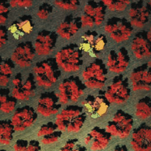
Remote and proximal sensing platforms at the service of precision olive growing are bringing new development possibilities to the sector. A proximal sensing platform is close to the vegetation, while a remote sensing platform, such as unmanned aerial vehicle (UAV), is more distant but has the advantage of rapidity to investigate plots. The study aims to compare multispectral and hyperspectral data acquired with remote and proximal sensing platforms. The comparison between the two sensors aims at understanding the different responses their use can provide on a crop, such as olive trees having a complex canopy. The multispectral data were acquired with a DJI multispectral camera mounted on the UAV Phantom 4. Hyperspectral acquisitions were carried out with a FieldSpec® HandHeld 2™ Spectroradiometer in the canopy portions exposed to South, East, West, and North. The multispectral images were processed with Geographic Information System software to extrapolate spectral information for each cardinal direction’s exposure. The three main Vegetation indices were used: normalized difference vegetation index (NDVI), normalized difference red-edge index (NDRE), and modified soil adjusted vegetation index (MSAVI). Multispectral data could describe the total variability of the whole plot differentiating each single plant status. Hyperspectral data were able to describe vegetation conditions more accurately; they appeared to be related to the cardinal exposure. MSAVI, NDVI, and NDRE showed correlation r =0.63**, 0.69**, and 0.74**, respectively, between multispectral and hyperspectral data. South and West exposures showed the best correlations with both platforms.
How to Cite

This work is licensed under a Creative Commons Attribution-NonCommercial 4.0 International License.

